


Dunhuang UNESCO Global Geopark
Dunhuang UNESCO Global Geopark(敦煌世界地质公园) is located in Dunhuang City, Gansu Province, China. The park covers an area of 2,180.75 square kilometers and includes the Yardang Scenic Area (雅丹景区), Mingsha Mountain (鸣沙山) and Crescent Moon Spring (月牙泉) Scenic Area, along with natural landscapes and cultural heritage sites. The unique geological features created by extreme arid climate conditions, combined with its geographical location along the ancient Silk Road, form a harmonious fusion of nature and culture. The Yardang landforms, Mingsha Mountain, Crescent Moon Spring, as well as the desert, Gobi, and West Lake Wetlands, represent natural wonders. In contrast, the Mogao Caves (莫高窟), ancient Silk Road cultural relics like Yangguan (阳关) and Yumenguan (玉门关), and ancient military sites such as the Han Great Wall (汉长城) and Hecang City (河仓城) embody the rich cultural history of Dunhuang.
On September 19, 2015, Dunhuang Geopark was successfully included in the UNESCO Global Geoparks Network and was granted the title of “Dunhuang Global Geopark.” It is the first geopark in Gansu Province, the 32nd in China, and the 113th globally.
Name: Dunhuang Global Geopark (敦煌世界地质公园)
Location: Dunhuang City, Gansu Province, China
Climate: Warm temperate extreme arid climate
Area: 31,200 square kilometers
Vegetation: Primarily grasslands and deserts
Geographical Environment
Location
Dunhuang UNESCO Global Geopark is located in the Dunhuang Basin, Gansu Province, China, which lies at the junction of Gansu, Qinghai, and Xinjiang. Dunhuang City covers an area of 31,200 square kilometers, with the geopark spanning 2,067.2 square kilometers. Its geographic coordinates range from 92°59′ to 94°47′ east longitude and 39°53′ to 40°34′ north latitude. The city borders Guazhou County (瓜州县) to the east and is adjacent to Subei Mongolian Autonomous County (肃北蒙古自治县) and Aksai Kazakh Autonomous County (阿克塞哈萨克族自治县) to the south. Key routes including National Highway 215 (国道215) and Provincial Highway 313 (省道313) pass through the region. The newly expanded 4C-level Dunhuang Airport (敦煌机场) connects directly to major cities such as Beijing, Lanzhou, Xi’an, Urumqi, Tianjin, and Chengdu. The Dunhuang Tourism Railway (敦煌旅游铁路) connects the Lanzhou-Xinjiang Railway (兰新铁路) with the Qinghai-Tibet Railway (青藏铁路), making access to the region easy. Local sightseeing lines connect all major scenic spots in Dunhuang.
Terrain and Landforms
Dunhuang UNESCO Global Geopark is situated within the Dunhuang Basin, with higher elevations in the north and south, and a lower central region. The area’s landforms are primarily wind-eroded and wind-accumulated, with intermittent flooding contributing to its unique landscape. The overall terrain slopes from east to west. Mingsha Mountain (鸣沙山), located in the eastern part of the park, rises to an elevation of 1,650 meters, while the western part of the park has a minimum elevation of 814 meters. The main landforms include mountains, plains, and basins. The park features various landscape types, such as Yardang (雅丹), Gobi (戈壁), desert, wetland, and oasis. Yardang, Gobi, and desert are typical landforms of extreme arid regions.
Climate Characteristics
Dunhuang lies in the northwest inland region of China, far from the ocean, and is situated at the center of the Central Mongolia Arid Zone. It has a typical warm temperate extreme arid climate, characterized by dry conditions, low rainfall, high evaporation, cold winters, hot summers, large seasonal and daily temperature variations, abundant sunshine, high radiation, and frequent strong winds.
Annual Average Temperature: 1.4–17.8°C
Monthly Average Temperatures: January (lowest), July (highest)
Frost-Free Period: 139–193 days
Annual Precipitation: 39.9 mm (concentrated in June, July, and August)
Annual Evaporation: Over 60 times the precipitation, reaching 2,846 mm
Annual Sunshine Hours: 3,053.3 to 3,483.9 hours
Total Solar Radiation: 6,418.58 MJ/square cm
Prevailing Winds: Calm winds and northeast winds, with an average wind speed of 2.2 meters per second
Hydrology
Crescent Moon Spring (月牙泉)
Crescent Moon Spring, also known as Sha Jing (沙井) or Medicine Spring (药泉), has been one of the “Eight Scenic Spots of Dunhuang” since the Han Dynasty. The spring is 200 meters long from east to west and 25 meters wide from north to south. The average depth of the water is 0.8 meters, earning it the title of “The First Spring in the Desert.”
Shule River (疏勒河)
The Shule River is an inland river originating from the western end of the Qilian Mountains (祁连山脉). It flows into the northeastern boundary of Dunhuang City, passing through Changma (昌马), Yumenguan Town (玉门镇), and other areas.
Dang River (党河)
The Dang River is a major inland river in the Shule River system within Dunhuang City. It originates from the Bungkundaban Pass (崩坤达坂) on the southern slopes of the Qilian Mountains, with water sources from glaciers such as Zailimuke (宰力木克) and the north and south glaciers of Ba Yin Ze Ri Ken Ule (巴音择日肯乌勒) and Nuo Gan Nuo Er (诺干诺尔). The Dang River’s water mainly comes from the melting glaciers and snow on the northern slope of the Qilian Mountains.
Dang River Reservoir (党河水库)
The Dang River Reservoir is located at the mouth of the Dang River, 36 kilometers north of Dunhuang City. The reservoir has a drainage area of 16,600 square kilometers and an average annual runoff of 293 million cubic meters. The dam is 46 meters high, with a total capacity of 15 million cubic meters. The top elevation of the dam is 1,421.5 meters. The reservoir is designed to withstand a 50-year flood, with a check for a 500-year flood. It was completed and became operational in 1975.
Soil
The soil types in the area of Dunhuang UNESCO Global Geopark can be divided into 7 main categories, 24 subcategories, 25 soil types, and 38 soil species. These include floodplain soils, saline soils, desert soils, brown desert soils, meadow soils, and marsh soils, among others.
Vegetation
The vegetation types in Dunhuang UNESCO Global Geopark and the surrounding areas are mainly grasslands and deserts, with some meadows, shrublands, and broadleaf forests. Due to the influence of the southeast monsoon and the high mountainous regions of the western Qilian Mountains, the distribution of zonal vegetation is affected by non-zonal conditions, disrupting the normal distribution patterns. There are roughly 6 main vegetation groups: broadleaf forests, grasslands, deserts, shrublands, alpine cushion vegetation, and meadows. The predominant types are grasslands, deserts, and shrublands.
Natural Resources
Plant Resources
There are 168 species of seed plants in Dunhuang UNESCO Global Geopark, including 2 species of gymnosperms and 166 species of angiosperms. These belong to 30 families and 105 genera, such as Ephedra (麻黄科), Salicaceae (杨柳科), Ulmaceae (榆科), Chenopodiaceae (藜科), Caryophyllaceae (石竹科), Ranunculaceae (毛茛科), Papaveraceae (罂粟科), Cruciferae (十字花科), Rosaceae (蔷薇科), Leguminosae (豆科), Zygophyllaceae (蒺藜科), Tamaricaceae (柽柳科), Malvaceae (锦葵科), Elaeagnaceae (胡颓子科), Cynomoriaceae (锁阳科), Umbelliferae (伞形科), Primulaceae (报春花科), Balsaminaceae (白花丹科), Nerium (夹竹桃科), and others.
Animal Resources
Dunhuang UNESCO Global Geopark is home to 196 species of wildlife, including 141 bird species, 32 mammal species, 8 fish species, 2 amphibian species, and 13 reptile species. Among these, 8 species are under first-class national protection, and 33 species are under second-class national protection.
Mammals
Wild mammals include species such as raccoons, rabbits, wild horses, wild camels, wolves, foxes, gazelles, hedgehogs, weasels, wildcats, otters, lynxes, musk deer, and deer.
Birds
Bird species include eagles, hawks, owls, crows, pigeons, ducks, swans, sand grouse, pheasants, geese, warblers, sparrows, swallows, nightjars, doves, cuckoos, barn owls, magpies, storks, kites, and mosquitobird.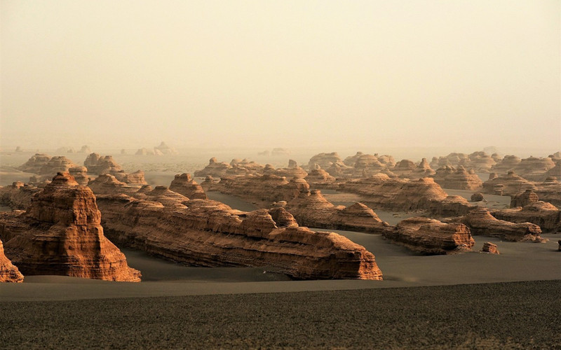
Geological Heritage
Material Composition
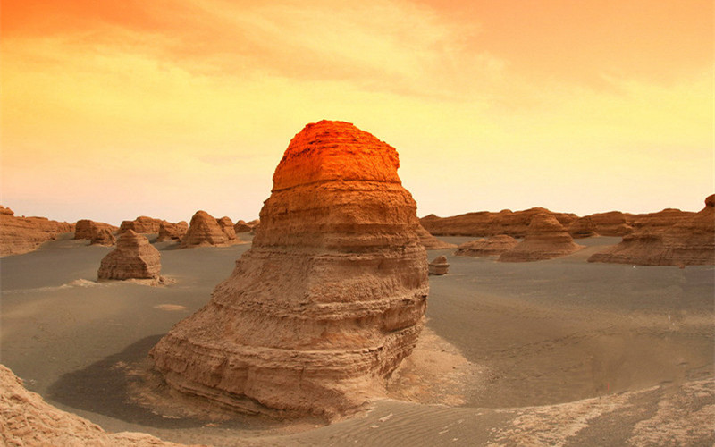
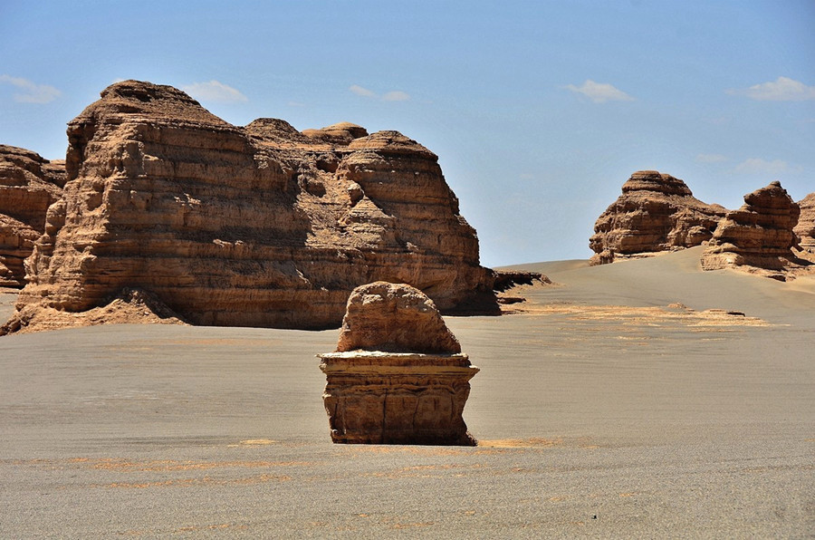
Dunhuang UNESCO Global Geopark is rich in geological relics that hold special significance. These relics include landform features, structural geological relics, sedimentary structures, stratigraphic relics, and water body landscape relics. Among these, the most iconic and scientifically valuable are the Yardang landforms and Mingsha Mountain.
The Yardang landforms in Dunhuang are a typical example of wind erosion. They are composed of unconsolidated sand and mud layers formed during the late Pleistocene and early Holocene periods in river and lake environments, primarily made up of silt and sand, with a minor amount of clay and gravel.
Mingsha Mountain (鸣沙山) is formed by the accumulation of flowing sands. The highest elevation is 1,650 meters. The sand is composed of five colors—red, yellow, green, white, and black—with white sand being the most abundant and yellow sand being the least. The grains are of uniform size and well-rounded, generally sub-rounded to round in shape, mostly opaque, with a glassy or frosted glass luster. The grain size typically ranges from 0.1 to 0.5 millimeters.
Stratigraphy
The stratigraphy of the area within Dunhuang UNESCO Global Geopark falls under the Tarim-North Xinjiang Stratigraphic Zone, specifically the Tarim Stratigraphic Region and the Tanan Stratigraphic Subregion. Due to the extensive coverage of Quaternary deposits and erosion by intrusive rock bodies, complete exposure of the strata is limited. The base layer consists of metamorphic rocks from the Archaean and Proterozoic eras, while the cover layers are primarily from the Jurassic and Neogene periods, with local deposits from the Ordovician, Silurian, Carboniferous, Permian, and Cretaceous periods.
Stratigraphic Relics
Mogao Caves Stratigraphy (莫高窟洞穴地层)
The Mogao Caves are located 25 kilometers southeast of Dunhuang City, between the Sanwei Mountains (三危山) to the east and Mingsha Mountain (鸣沙山) to the west. The cave complex is carved into the steep cliffs on the west bank of the Daqing River (大泉河), stretching approximately 1,600 meters in length and 25 meters in height. There are 492 caves containing relics and around 200 abandoned caves. The strata at Mogao Caves consist of three layers:
Lower Pleistocene: Ice-water deposits and debris from the Yuemen Formation (玉门组) in the form of conglomerates.
Middle Pleistocene: Fluvial deposits from the Jiayuguan Formation (酒泉组), characterized by semi-consolidated conglomerates.
Upper Pleistocene: Alluvial deposits from the Gobi Formation (戈壁组), consisting of sand and gravel layers.
The Jiayuguan Formation (酒泉组) is found in the Sanwei Mountains and Xiaohongshan foothills, as well as at the western edge of the alluvial fan. It covers an area of about 60 square kilometers. The formation consists of greyish-white gravel, cemented with calcium mud, and is dense in structure with irregular medium to fine sand lenses. The composition includes granite, quartzite, gabbro, shale, schist, and limestone. The mineral content of the gravel includes quartz, feldspar, calcite, pyroxene, hornblende, and biotite.
Landform Relics
Yardang Scenic Area Fault (雅丹景区南缘断层)
The fault is located at the southwestern edge of the Yardang Scenic Area (雅丹景区), formed by tectonic compression. The fault strikes east-west, with a northwest dip, and has a width of approximately 3.5 meters. The fault surface has a prominent fracture, with a fault cliff around 5 meters high. The fault zone contains angular breccia and fault clay, with the breccia showing a yellow color and good cementation, with angular to sub-rounded fragments of varying sizes.
Geological Structure
Dunhuang Basin, located at the western end of the Hexi Corridor, lies on the Dunhuang Block, which is part of the eastern Tarim Plate. The eastern part of the Dunhuang Basin belongs to the North China Plate, the northern part to the Junggar Plate, and the southern part to the Qinghai-Tibet Plate. The basin runs in a northeast-southwest direction, forming a unique sedimentary basin that connects different tectonic plates and separates and reconfigures ancient structural systems.
From south to north, the basin is divided by two large basement uplifts: the Dongbatushan (东巴兔山) and Sanwei Mountain (三危山), naturally splitting the basin into three subbasins: the Anxi Depression (安西坳陷), Tashi Depression (踏实坳陷), and Aksai Depression (阿克赛坳陷). The basin is approximately 400 kilometers long from east to west and 80-120 kilometers wide from north to south, covering an area of about 40,000 square kilometers. Major rivers in the basin include the Shule River (疏勒河) and Dang River (党河), and the central area contains numerous small saline lakes, marshes, and wetlands.
The characteristics of recent tectonic movements in the region are as follows:
Time: The major faults in the Dunhuang area primarily formed before the Paleogene period, with strong activity during the Quaternary, particularly in the later stages.
Space: The Altyn Mountains (阿尔金山) front fault cuts through the Quaternary strata, with deep incisions in the Gobi and rivers flowing at an angle. The boundary between the northern block, which is relatively stable, and the southern block, which has undergone intense faulting, is marked by the Shule River-North Shihe (疏勒河-北石河) east-west hidden fault. The basin’s shape is “mountain-shaped,” with an uplift before the Pleistocene and subsequent subsidence in some areas. The reflection arc structure in the Yumenguan area (玉门关) shows symmetrical “eight-shaped” Quaternary basins on both sides of the arc.
Geological Relic Scenic Areas and Protection Zones (in Square Kilometers)
| Geological Relic Scenic Area | Special Protection Area | First Protection Area | Second Protection Area | Third Protection Area |
|---|---|---|---|---|
| Yardang Scenic Area (雅丹景区) | – | 4.47 | 36.21 | 346.35 |
| Mingsha Mountain-Crescent Moon Spring Scenic Area (鸣沙山-月牙泉景区) | 0.016 | – | 9.56 | 247.93 |
| Total | 0.016 | 4.47 | 45.77 | 130.26 |
Special Protection Area
The Special Protection Area (特级保护区) is the core protected region of the geopark, with an area of 0.016 square kilometers, primarily focused on protecting Crescent Moon Spring (月牙泉). Access is strictly prohibited for tourists, and only approved researchers and management personnel may enter for conservation and scientific activities. No infrastructure is allowed in this area.
First Protection Area
The First Protection Area (一级保护区) covers an area of 4.47 square kilometers and focuses on protecting the well-organized, densely distributed, and large-scale Yardang (雅丹) landforms within the Yardang Scenic Area (雅丹景区). The area allows the construction of essential pathways for tourism but prohibits tourists from climbing the Yardang landforms. No construction projects unrelated to the protection of geological relics are allowed, and motorized vehicles are banned. The responsibility for protecting this area is strictly assigned to specific individuals.
Second Protection Area
The Second Protection Area (二级保护区) is the main distribution zone for geological relics, with minimal human influence. Some basic infrastructure for tourism services can be developed, but the construction style must be compatible with the surrounding natural environment.
Third Protection Area
The Third Protection Area (三级保护区) includes all other geological relic protection zones outside of the above-mentioned areas. Some necessary tourism facilities can be built here, but they must be appropriately scaled and harmonize with the surrounding landscape.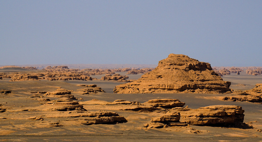
Geoscience Museums
Yardang Geoscience Museum (雅丹地学博物馆)
The Yardang Geoscience Museum (雅丹地学博物馆) is located within the Yardang National Geological Park (雅丹国家地质公园) and was established in 2006. The museum covers an area of 800 square meters, including a 500-square-meter cinema hall where visitors can view panoramic videos on geological landscapes and the formation process of geological relics. The museum’s 300-square-meter exhibition space integrates natural landscapes and man-made displays in a seamless manner, complementing one another.
The museum is divided into three exhibition halls:
The control factors in the formation of Yardang landforms (雅丹地貌)
The geological background and landscape types of Yardang
The Yardang landforms in China and around the world, as well as the geopark and Earth knowledge
The museum showcases nearly a hundred different specimens of Yardang, using simple language and concise images to comprehensively and meticulously introduce visitors to the fundamental knowledge of Yardang Landforms (雅丹地貌), its unique geological resources, the region’s long history, and the geological research outcomes from Dunhuang (敦煌).
Mogao Caves Geoscience Exhibition Hall (莫高窟陈列厅)
Located at the Mogao Caves Visitor Center (莫高窟游客接待中心), the Mogao Caves Geoscience Exhibition Hall (莫高窟地学陈列厅) occupies 100 square meters. This exhibition hall is dedicated to showcasing the current status, history, and artistic achievements of the Mogao Caves (莫高窟), the natural conditions that have contributed to its preservation, its geological environment, environmental geological hazards, and preventative measures.
Visitors can experience the treasures of Eastern art while also enhancing their understanding of geoscience, providing a deeper cultural and geological perspective on the Mogao Caves.
Tourism Information
Ticket Prices for Yardang Scenic Area (雅丹景区)
Full Price: ¥120 (Ticket: ¥50, Sightseeing Bus Ticket: ¥70)
Discounted Price: ¥95 (Ticket: ¥25, Sightseeing Bus Ticket: ¥70)
Opening Hours: 7:00 AM – 7:00 PM
Special Discount for the 2024-2025 Study & Exhibition Season
From December 1, 2024, to February 28, 2025, Dunhuang Yardang UNESCO Global Geopark (敦煌雅丹世界地质公园) will offer free admission to all domestic and international visitors as part of the 2024-2025 study season, conference season, and winter-spring tourism promotion measures in Dunhuang (敦煌), Gansu Province (甘肃省).


