Quick Answer: How Do You Plan a Trip to Xinjiang?
A Xinjiang travel guide has to cover four different regions, because Xinjiang (新疆) is the size of Iran. The four are Turpan and Urumqi (吐鲁番 / 乌鲁木齐) in the east — the Silk Road oasis gateway with Flaming Mountains and the ancient Karez wells; Kashgar (喀什) in the far southwest — the western terminus, Uyghur old town, and Sunday Bazaar; Northern Xinjiang (北疆) — Kanas Lake, Hemu village, and the Ili grasslands; and Southern Xinjiang (南疆) — the Taklamakan Desert Highway, Hotan, and the Pamir Plateau. Foreign visitors need to plan for hotel foreign-registration rules, an unofficial two-hour time difference from Beijing, and long driving distances. Itineraries run from 5 days (Urumqi + Turpan) to 23 days (full panorama).
Key Takeaways
✔ Xinjiang splits into four travel regions — Turpan/Urumqi gateway, Kashgar, Northern Xinjiang (Kanas/Ili), and Southern Xinjiang (Taklamakan/Pamir). Most first-time trips combine two.
✔ The best first-visit route is Northern Xinjiang in summer (June–August) — Kanas Lake, Hemu village, Sayram Lake, and the Ili grasslands deliver the alpine-oasis scenery most people imagine, with no altitude concerns.
✔ Hotel foreign-registration is the single biggest logistical friction — many county-town hotels and boutique guesthouses are not licensed to accept foreign passports, and small towns may only have one or two licensed options.
✔ Xinjiang runs on Beijing time officially but functions on an unofficial ~2-hour local schedule — restaurants, shops, and daily life shift by two hours, and the sun does not set until 10 p.m. in summer.
✔ Border-zone destinations (Tashkurgan, Karakoram Highway to Karakul Lake, Ili's border strip, Kanas–Baihaba) require a Border Management Area Permit — for foreign visitors this must be applied in person at a county-level public-security office, not online.
✔ Halal food is the default across most of Xinjiang; naan, lamb skewers, laghman noodles, pilaf, and dry fruits from Turpan and Hotan are the everyday standard, not a specialty item.
✔ Trip length: 5–7 days for a Urumqi/Turpan taster, 10–13 days for one region in depth, 17–23 days for a full Silk Road corridor combining Xinjiang with Gansu and Xi'an.
Book a full Xinjiang panorama
Tour Route:Urumqi-Kanas Lake-Karamay-Aksu-Kashgar-Korla-Turpan
 23 Days
 10 Places
Why Xinjiang Is the Anchor of the Western Silk Road
 Karakul Lake and Mount Muztagh Ata Pamir Xinjiang
 Kashgar Old Town Uyghur architecture Xinjiang
Xinjiang is where the historical Silk Road split, ran, and eventually met the outside world. Every oasis you visit — Turpan, Kuqa, Kashgar, Hotan, Yarkant — was a caravanserai stop, a Buddhist center, or a market where Persian, Sogdian, Uyghur, and Chinese traders met. Modern Xinjiang travel is about following that same corridor with paved roads and high-speed trains, but the geography, food, and Uyghur cultural life are still recognizably Silk Road.
- Sheer scale. Xinjiang covers 1.66 million km² (641,000 sq mi) — one-sixth of China's land area, and larger than any European country. Driving between adjacent "nearby" cities regularly takes 8–10 hours.
- Four distinct travel regions. The Turpan-Urumqi gateway, Kashgar and the Pamir, Northern Xinjiang's alpine lakes, and Southern Xinjiang's desert oases each need their own itinerary — you cannot see all four in a week.
- UNESCO-scale Silk Road heritage. Jiaohe (交河故城) and Gaochang (高昌古城) ruins, the Bezeklik Thousand Buddha Caves, the Karez underground water system, Subashi Buddhist ruins in Kuqa, and Kashgar's Old Town anchor 2,000 years of trade-route history.
- Living Uyghur, Kazakh, Tajik and Mongol culture. Sunday Bazaar in Kashgar, the Tuva villages of Kanas, Kyrgyz herders around Karakul Lake, Kazakh yurts at Sayram Lake — the ethnic diversity is the trip.
- Alpine scenery outside China's usual circuit. Kanas Lake's turquoise water, Hemu's log-cabin morning mist, Sayram's snow-and-lake reflections, Bayinbuluk's swan grasslands — none of it looks like the Great Wall or Guilin.
- Silk Road food that is naturally halal. Lamb, mutton, naan (馕), dapanji (大盘鸡), laghman (拉条子), samsa, dry-fruit stalls in every bazaar — Xinjiang cuisine is one of the strongest regional cuisines in China.
- A jumping-off point for Central Asia. Urumqi and Kashgar are the only viable land gateways from China into Kazakhstan, Kyrgyzstan, Tajikistan, and Uzbekistan.
The Four Travel Regions of Xinjiang: Which One to Pick
For a first-time Xinjiang trip, the choice is not "everything" — it is "which two regions can I combine in the time I have?" This section walks through each region, what it delivers, what it costs in travel days, and which itineraries fit.
1. Turpan and Urumqi (吐鲁番, 乌鲁木齐) — The Silk Road Gateway
 Jiaohe Ruins earthen city Turpan
 Karez underground water system Turpan
The bus from Urumqi drops into the Turpan Depression and the temperature climbs 10°C in an hour. By afternoon, the black stone of the Flaming Mountains (火焰山) glares in 45°C heat, and cool air rises out of the Karez underground channels where locals have shuttled snowmelt for two thousand years. This is the eastern gateway to Xinjiang and the shortest Silk Road introduction.
Fact Panel — Turpan / Urumqi Gateway
- Route / Location: Urumqi ↔ Turpan (2.5–3 hour drive, 190 km / 118 mi), or fly into Urumqi Tianshan International Airport (URC)
- Duration: 2–5 days
- Best Time: April–June and September–October (summer heat exceeds 40°C / 104°F in Turpan; winter is cold but clear)
- Difficulty: Low — good highways, well-developed tourist infrastructure
- Highlights: Jiaohe Ruins, Karez Well System, Sugong (Emin) Minaret, Flaming Mountain, Bezeklik Thousand Buddha Caves, Gaochang Ancient City, Heavenly Lake (天山天池), Grand Bazaar, Xinjiang Museum's Silk Road mummies
- Accommodation: Foreign-registration-licensed hotels widely available in both Urumqi and Turpan city; less so in smaller Turpan county areas
Turpan is where Silk Road history feels most direct. Jiaohe Ruins, sitting on a leaf-shaped plateau between two river valleys, is the largest and oldest surviving earthen city in the world, with Tang-dynasty temple foundations still readable in the packed loess. The Karez Well System — a network of vertical shafts and underground canals dug 2,000 years ago to channel snowmelt from the Bogda Mountains under the desert without evaporation — is one of the three great ancient engineering projects in China. Urumqi itself is a modern provincial capital with a metro, tap-to-pay, and the Grand Bazaar that anchors the city center — a useful acclimatization stop before flying south to Kashgar or driving into the north.
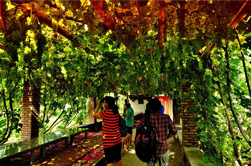
Skip the "Turpan Grape Valley + costume-photo village" package that appears on many domestic day tours — it is a staged photo stop that has little to do with real Turpan life. Instead, book a family visit in a working Uyghur vineyard around Putaogou, or go in late August when actual grape harvest is happening. The Karez site paired with a working village visit gives you the real story of the water system.
Explore the Urumqi and Turpan gateway
Tour Route:Urumqi-Urumqi-Urumqi
5 Days 2 Places View DetailFor city-level depth on Turpan's oasis sites and the Urumqi–Heavenly Lake day loop, see our Turpan travel guide and Urumqi and Heavenly Lake guide .
2. Kashgar (喀什) — The Western Terminus
 Id Kah Mosque yellow facade Kashgar Old Town
 Kashgar Sunday Bazaar stalls Uyghur market
The Id Kah Mosque's yellow facade catches afternoon light; across the square, a coppersmith hammers a tray flat and a tea house fills with men in doppa caps. Kashgar is the western terminus of the Chinese Silk Road, the last major Chinese city before the Pamir Plateau, and the emotional peak of most Xinjiang trips.
Fact Panel — Kashgar and the Pamir
- Route / Location: Fly Urumqi → Kashgar (1h 45m); Kashgar → Karakul Lake / Tashkurgan (280 km / 174 mi via Karakoram Highway G314)
- Duration: 3–5 days for Kashgar city + Karakul; 5–7 days including Yarkant and Hotan
- Best Time: May–October (Karakoram Highway to Karakul closes with snow in winter)
- Difficulty: Low in Kashgar city; Medium for Karakul Lake at 3,600 m (11,800 ft) — mild altitude
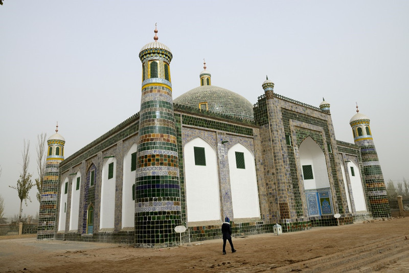
- Highlights: Kashgar Old Town, Id Kah Mosque, Sunday Bazaar, Abakh Hoja Tomb, Handicraft Street, Karakul Lake, Mount Muztagh Ata (7,509 m / 24,636 ft), Stone City ruins, Tashkurgan
- Accommodation: Foreign-registration-licensed hotels widely available in Kashgar city; limited in Tashkurgan
Kashgar Old Town is what draws most travelers — narrow alleys of mud-brick houses, artisan streets where blacksmiths, hat-makers, and bakers work in view, and the Id Kah Mosque, built by Saqsiz Mirza in 1442. The Sunday Bazaar spreads over 0.17 km² with more than 5,000 stalls; drive four hours south on the Karakoram Highway and you climb from Kashgar's 1,300 m to Karakul Lake at 3,600 m, with Mount Muztagh Ata — the "father of ice mountains" — rising above the water at 7,509 m. Tashkurgan (Stone Fortress) is the last Chinese town before the border; foreign visitors can go this far with a Border Management Area Permit, but the Khunjerab Pass border crossing itself is only open to foreigners with a valid Pakistan visa and the intent to cross into Pakistan — not as a sightseeing day trip.
Skip the pre-packaged "Old Town cultural performance" pushed by some domestic operators — dancers in costume performing on a stage for tour groups is a manufactured show. Real Uyghur music happens at Kashgar tea houses in the Old Town in the late afternoon; find one where old men sit with dutars, not one with a "Cultural Show" sign in English.
Deep-dive Kashgar and the Pamir
For the full Kashgar city guide, the Sunday Bazaar, and the Karakoram Highway drive to Karakul, see our Kashgar travel guide .
3. Northern Xinjiang (北疆) — Kanas, Hemu, Sayram, Ili
 Hemu Village Tuva wooden houses autumn birch
 Kanas Lake autumn golden birch forest reflection
Cold blue water, birch forest, and log cabins under morning mist — Kanas Lake at sunrise is what most foreign visitors did not know China had. Northern Xinjiang is the alpine-lake, grassland, and forest region, and for a first Xinjiang trip it is the strongest recommendation: mature tourism infrastructure, no altitude concerns, and the scenery lives up to every expectation.
Fact Panel — Northern Xinjiang
- Route / Location: Loop from Urumqi: Urumqi → Burqin → Kanas Lake (布尔津 → 喀纳斯) → Hemu (禾木) → Karamay → Sayram Lake (赛里木湖) → Yining (伊宁) → Nalati / Bayinbuluk (那拉提 / 巴音布鲁克) → back
- Length: ~2,500–3,000 km driven over the loop
- Duration: 10–13 days for the full loop; 7 days for Kanas + Hemu only
- Best Time: Late June–early July (wildflowers, long daylight); September (autumn foliage at Kanas and Hemu) — this is the most weather-dependent region
- Difficulty: Low–Medium — long driving days (Urumqi to Burqin is ~700 km / 435 mi, 8–10 hours); altitude max around 2,500 m (8,200 ft)
- Highlights: Kanas Lake, Hemu Village Tuva log-cabin community, Wucaitan (Colorful Bay), Urho Ghost City, Sayram Lake, Nalati Grassland, Bayinbuluk Swan Lake, Ili Valley
- Accommodation: Foreign-registration-licensed hotels are limited in Kanas, Hemu, and small Ili towns — advance booking through an agency is important
Kanas Lake sits in the Altay mountains at 1,375 m, its water fed by Altay glacier melt in the summer and shifting through greens and blues depending on light and season. Hemu village, 70 km south, is a Tuva community of wooden houses in a valley; famous for autumn birch color in mid-September and for early-morning mist that rises off the meadows. Sayram Lake, the largest and highest alpine lake in Xinjiang, sits in a basin between the northern Tianshan and the Ili grasslands — the drive over the Guozigou Bridge is one of the most photographed roads in China. The Ili Valley then opens into the grasslands: Nalati's "Sky Grassland," Bayinbuluk's Swan Lake Nature Reserve, and Kalajun.
From our team on the ground: For first-time visitors to Xinjiang who ask us where to go, we send them north. The alpine-and-oasis scenery is what they expect and it lives up to it, driving between sights is straightforward, and there are no altitude issues to plan around — southern Xinjiang and the Pamir get the "next visit" recommendation once travelers know what they like.
The most common Northern Xinjiang mistake is booking a "7 cities in 7 days" itinerary that spends most of the trip on the highway. Distances here are enormous — Urumqi to Kanas alone is 700+ km. A better rhythm is 10–13 days that lets Kanas, Hemu, and one Ili valley destination each get two nights, with driving days broken by a real scenic stop. Ask any Xinjiang-based operator to redraw an itinerary that has more than one 8+ hour drive day.
Photograph Northern Xinjiang (13-day loop)
Tour Route:Urumqi-Kanas Lake-Karamay-Turpan-Heavenly Lake (Tianchi) in Xinjiang-Urumqi
13 Days 6 Places View DetailFor the alpine-lake and Ili grassland deep-dive covering Kanas, Hemu, and Sayram, see our Northern Xinjiang and Kanas Lake guide .
4. Southern Xinjiang (南疆) — The Desert and the Pamir
 Taklamakan Desert shifting dunes Xinjiang
 Kizil Grottoes Buddhist murals Kuqa Xinjiang
South of Turpan the road runs along the Taklamakan Desert (塔克拉玛干沙漠) — 337,000 km² of shifting sand, the world's second-largest mobile desert. Southern Xinjiang connects Kashgar back to Turpan through Kuqa, Aksu, and Hotan, and is where the Silk Road's southern branch ran through oasis kingdoms like Loulan and Khotan.
Fact Panel — Southern Xinjiang and Taklamakan
- Route / Location: Urumqi → Turpan → Korla → Kuqa → Aksu → Kashgar → Karakul → Yarkant → Hotan (loop back via Taklamakan Desert Highway or fly)
- Length: ~2,800 km / 1,740 mi for the full southern loop
- Duration: 11–12 days
- Best Time: April–May and September–October (avoid July–August summer heat exceeding 40°C / 104°F in the desert)
- Difficulty: Medium — long distances, remote sections, some difficult driving days
- Highlights: Kizil Grottoes, Kuqa Old Town and Mosque, Subashi Ruins, Taklamakan Desert Highway, Atlas silk workshops in Hotan, Yarkant King Tombs, Karakul Lake, Diversifolious Poplars Park (Populus euphratica forest)
- Accommodation: Foreign-registration-licensed hotels limited in Hotan county, Yarkant, and small oasis towns
The southern route is where you see the Silk Road as trade route — dry, ancient, and framed by desert. The Kizil Grottoes near Kuqa are the earliest major Buddhist cave complex in China, with murals from the 3rd–8th centuries that predate Dunhuang's Mogao Caves. In Hotan the traditional Atlas silk workshops still weave with hand looms, and the Diversifolious Poplars Park along the Tarim River holds the world's largest natural forest of Euphrates poplar — the trees turn gold in October and stand black-trunked against desert sand. Yarkant King Tombs, first built in 1533, still retain their classic Uyghur wall decoration.
Southern Xinjiang "desert camp" experiences vary enormously in quality — some are staged tents with generator lighting set up an hour from the highway. If you want a real desert night, ask specifically for camps run by long-established local Uyghur operators (Yaso Trip works with several), not the branded resort-style camps that market on Chinese social media.
Cross Southern Xinjiang and the Taklamakan Highway
Tour Route:Urumqi-Turpan-Korla-Ye'erqianghan Mausoleum in Yarkant County, Kashgar-Kashgar
12 Days 6 Places View Detail5. Desert and Remote Adventure — Lop Nur, Loulan, Kumtag
 Lop Nur desert Milky Way Galaxy Xinjiang
 Kumtag Desert in Shanshan County, Turpan
The dried center of Lop Nur (罗布泊) is where the ancient Loulan Kingdom disappeared. This is not a mainstream trip — it is Xinjiang for travelers who have already seen the north and Kashgar and want to see the Silk Road at its rawest.
Fact Panel — Lop Nur / Loulan / Kumtag Adventure
- Route / Location: Urumqi → Turpan → Kumtag Desert → Dragon City Yardangs → Lop Nur → Loulan Ancient City → Kumtag Desert → Dunhuang (crosses into Gansu)
- Duration: 9 days
- Best Time: April–May and October (avoid summer heat and winter cold)
- Difficulty: Very High — requires professional off-road support, medical kit, and advance permit
- Highlights: Dragon City Yardangs on north bank of Lop Nur, dried Lop Nur lakebed, Loulan Ancient City ruins, Kumtag Desert (2,500 km²), Yumen Pass and Great Wall of Han Dynasty
- Accommodation: Multi-night desert camping in professional convoy camps
The Lop Nur core zone is a strictly controlled area. Unauthorized entry is prohibited, actively enforced with monitoring, and violators face fines and detention. Foreign visitors can access Loulan and the surrounding desert only through a licensed operator that files a special-purpose permit 1–3 months in advance; costs are significant. This is not a route to attempt independently.
Book a Lop Nur / Loulan expedition
Tour Route:Urumqi-Turpan-Dunhuang
9 Days 6 Places View Detail Silk Road highway Hexi Corridor Gansu convoy
Id Kah Mosque in Kashgar muslim heritage 6. The Silk Road Cross-Corridor: From Xinjiang into Gansu
If your Xinjiang trip is part of a longer Silk Road journey, the natural crossing point is Dunhuang↔Urumqi. Silk Road-branded corridor tours travel this connection in 8–9 days, and pair Turpan/Kashgar with the Mogao Caves and Zhangye Danxia across the border in Gansu.
Combine Xinjiang with the Hexi Corridor
Tour Route:Beijing-Urumqi-Kashgar-Urumqi-Dunhuang-Jiayuguan-Lanzhou-Xiahe-Tongren-Xining-Xian
17 Days 5 Places View DetailFor a full multi-week Silk Road journey — Xi'an, Gansu, Xinjiang — see our Gansu Silk Road Guide and the parent China Silk Road Tour pillar for full corridor context.
7. The Muslim / Halal Angle in Xinjiang
Halal food and prayer logistics are trivial in Xinjiang — the region's Uyghur, Kazakh, Kyrgyz, Tajik, and Hui communities make halal cooking the default rather than the exception. Restaurants that serve pork label themselves as 汉餐 (Han food) on their signboards for clarity. Mosques are in every town, and the Id Kah in Kashgar and the Sugong Minaret in Turpan are among the most historically important in China.
For a full breakdown of halal-specific itineraries, prayer logistics, certified restaurants, and Uyghur Muslim cultural context, see our Xinjiang Muslim Tour Guide .
Xinjiang Muslim tour — halal itinerary option
Tour Route:Urumqi-Turpan-Kashgar
7 Days 4 Places View Detail8. Beyond Xinjiang: Central Asia via Urumqi and Kashgar
Xinjiang is the only Chinese province with land connections to five Central Asian countries. From Urumqi you can drive out through Khorgos into Kazakhstan; from Kashgar, the Irkeshtam and Torugart passes cross into Kyrgyzstan, and the Karakoram Highway crosses into Pakistan via Khunjerab Pass (foreign visitors need a Pakistan visa and the pass is seasonally open Mon–Fri, roughly April–November). Self-drive convoys into five Central Asian countries — Kazakhstan, Kyrgyzstan, Uzbekistan, Tajikistan, and Turkmenistan — depart from Urumqi as a distinctive extension of the Silk Road.
Extend into Central Asia from Urumqi
Tour Route:Urumqi–Sayram Lake–Guozigou Bridge–Khorgos–Almaty–Medeu–Big Almaty Lake–Panfilov Park–Bishkek–Tokmok–Burana Tower–Issyk-Kul–Toktogul–Osh–Tashkent–Samarkand–Bukhara–Khiva–Darvaza–Ashgabat–Dushanbe–Khujand–Fergana Valley–Nukus–Muynak–Kashgar
Xinjiang Regions at a Glance
Xinjiang Travel Regions Comparison
Sample Itinerary: 11-Day Xinjiang Highlights (North + South)
This is the balance most first-time Xinjiang travelers land on: the northern alpine scenery around Kanas and Sayram, then a flight south to Kashgar and the Pamir, wrapped with the Silk Road heritage of Turpan.
11-Day Xinjiang Highlights Itinerary
Day 1
Arrive Urumqi
Land at Urumqi Tianshan International Airport (URC); rest, walk the Grand Bazaar in the evening.
Day 2
Urumqi → Burqin
Long transfer day north (~8–10 hours) via Wucaitan Colorful Bay Yardang landform.
Day 3
Kanas Lake
Shuttle-bus loop around Kanas; hike or take the boat; sunset from the viewing tower.
Day 4
Hemu Village
Drive to the Tuva log-cabin village; morning mist over the meadow; horseback ride optional.
Day 5
Hemu → Karamay → Sayram
Full driving day west via Urho Ghost City; overnight in a Kazakh yurt at Sayram Lake.
Day 6
Sayram → Ili → fly to Kashgar
Photograph the lake, drive down through Guozigou to Yining; evening flight to Kashgar.
Day 7
Kashgar Old Town
Id Kah Mosque, Handicraft Street, Abakh Hoja Tomb; slow afternoon in a tea house.
Day 8
Kashgar → Karakul Lake
Karakoram Highway drive to Karakul (3,600 m) below Mount Muztagh Ata; overnight Kyrgyz yurt or Tashkurgan.
Day 9
Kashgar Sunday Bazaar → fly Urumqi → Turpan
Return via Urumqi; onward drive to Turpan.
Day 10
Turpan Silk Road day
Jiaohe Ruins, Karez Well System, Sugong Minaret, Flaming Mountain, Bezeklik Caves.
Day 11
Turpan → Urumqi departure
Morning transfer back to Urumqi Tianshan International Airport for departure.
Book the 23-day Xinjiang Panorama
Tour Route:Urumqi-Kanas Lake-Karamay-Aksu-Kashgar-Korla-Turpan
23 Days 10 Places View DetailPractical Logistics: Permits, Hotels, Transport, Money
Best Time to Visit Xinjiang
Xinjiang has three distinct climate zones, and the "best time" depends on which region you are visiting.
Xinjiang Best Time by Region
Permits and Documentation for Foreign Visitors
Xinjiang requires no separate "Xinjiang travel permit" for entry into the province itself — a valid China visa is sufficient. Border-zone destinations, however, do require a Border Management Area Permit.
Where the border permit is required: Tashkurgan and the Karakoram Highway approach to Karakul Lake, the Ili border strip near Khorgos, parts of Bayinbuluk and Bortala, and the Kanas–Baihaba border stretch. If your itinerary includes any of these, a permit is mandatory.
How the permit works in 2026: From April 15, 2026, China's Border Management Area Permit moved to an electronic system (e-BMAP) for mainland residents. Foreign travelers, however, must still apply in person at a designated county-level public-security office in Xinjiang, present passport, hotel confirmation, and itinerary, and receive a permit that is destination-specific — one permit does not cover all Xinjiang border zones.
Since April 15, 2026, mainland residents apply for the electronic Border Management Area Permit online via the National Immigration Administration app. Foreign passport holders (and Hong Kong / Macao / Taiwan residents) are excluded from online application and must apply in person at a public-security office in the destination county. Plan for 1–3 working days per permit; separate permits are needed for different border zones. A licensed local operator handles the application on-site as part of the itinerary.
Lop Nur / Loulan special permit: The Lop Nur core zone requires a special-purpose permit issued through licensed operators, typically applied 1–3 months in advance. Independent entry is prohibited and enforced.
Khunjerab Pass to Pakistan: As of June 2026, the Khunjerab Pass border crossing is open to foreign visitors who hold a valid Pakistan visa, Monday–Friday, roughly April–November. Sightseeing to the border viewpoint without the intent to cross is generally not permitted for foreign passport holders.
Hotel Foreign-Registration Rules — The Biggest Logistical Trap
Not every hotel or guesthouse in Xinjiang is licensed to accept foreign passports. Ministry of Public Security rules require overnight registration for all foreign visitors, and only hotels that hold a foreign-registration license can process it. In Urumqi, Kashgar city, and Turpan city, licensed hotels are widely available. In smaller places — Kanas, Hemu, some Ili towns, county seats in Southern Xinjiang — the number of licensed hotels can drop to one or two per town, and many popular Chinese-social-media guesthouses cannot host you.
The consequence: independent booking through international OTAs regularly ends with a rejection at check-in and a scramble at 11 p.m. for a licensed alternative. Working with a Xinjiang-based operator solves this — a local team can pre-book foreign-registration-licensed rooms across the whole route and confirm them in advance. If you must book independently, ask the hotel directly by email whether it holds a "涉外资质" (foreign-reception license) before booking.
Getting Around: Airports, Rail, and Highways
Airports. Urumqi Tianshan International Airport (URC), formerly known as Diwopu, was renamed in March 2025. As of April 17, 2025, the airport consolidated into a single new Terminal 4 (T4) with two new north runways — Terminals 1, 2, and 3 all closed the same day. T4 is now the sole passenger terminal, and total airport capacity rose to 48 million passengers annually. Xinjiang also has regional airports at Kashgar (KHG), Hotan (HTN), Yining (YIN), Aksu (AKU), Kuqa (KCA), Turpan (TLQ), and others.
High-speed rail. The Lanzhou–Urumqi high-speed rail line reaches Urumqi from Gansu. A high-speed rail line from Urumqi to Kashgar / Hotan is in planning-study stage and not yet operational — south Xinjiang travel remains by conventional sleeper train (the ring-desert railway around the Taklamakan is a real, currently operating conventional line) or by flight.
Highways. The Wu–Yu Expressway (Urumqi to Yuli) shortened the drive from Urumqi toward Korla / Yuli from ~7 hours to ~3 hours — a significant recent improvement. Long-distance driving distances remain large, however: Urumqi to Kanas is 8–10 hours, Kashgar to Hotan is 7–8 hours. For the full corridor breakdown of trains, flights, and inter-city distances, see our Silk Road transportation guide .
Time zone. Xinjiang officially runs on Beijing time (UTC+8), but daily life in most of Xinjiang functions on unofficial "Xinjiang time" — roughly 2 hours behind Beijing. Restaurants open around 10 a.m., lunch is at 2 p.m., dinner at 8–9 p.m., and in summer the sun does not set until 10 p.m. Business appointments, train and flight schedules use Beijing time; everything else you experience runs on Xinjiang time. Ask your guide which time is being quoted for any pickup.
Money, Payment, and Communication
Xinjiang uses the same mobile-payment stack as the rest of China — WeChat Pay and Alipay are ubiquitous, cash is uncommon, and both apps now accept international credit cards. ATMs work with international debit cards in Urumqi, Kashgar, and Turpan cities but are rarer in county towns. Bring a physical passport with you at all times: hotel check-in, security checkpoints, some scenic-area ticketing, and petrol stations all require it. Buy a Chinese-market SIM in Urumqi (or use e-SIM); a local guide can arrange this on arrival.
Practical Experience: What Xinjiang Actually Feels Like
How to Handle the Passport and Checkpoint Rhythm
Foreign visitors in Xinjiang go through more passport checks per day than almost anywhere else in China. Expect passport scans at highway service stops, some scenic-area gates, petrol stations, and city entry points. Individual checks are usually fast — under a minute — but a busy checkpoint at a scenic area can add 15–20 minutes when the officer needs to log details manually. Two things reduce friction: keep your passport physically on you (not in a checked bag or the support vehicle), and travel with a Chinese-speaking guide who can answer the routine questions ("where from, where to, purpose of visit") in a sentence. A licensed guide handles this exchange as part of the day; independent travelers should expect the checkpoint rhythm to shape their pace.
How to Adjust to Xinjiang Time in the First 48 Hours
The unofficial 2-hour local time shift catches most foreign visitors off-guard. Practical tips: eat on the local schedule the day you arrive (a late lunch and 8–9 p.m. dinner) rather than trying to force Beijing time; do not book afternoon activities for immediately after lunch — locals are still eating; expect daylight until nearly 10 p.m. in summer and use blackout curtains at the hotel. Business schedules — flight, train — are always Beijing time; sightseeing schedules are usually Xinjiang time. Confirm which one your pickup time refers to.
How to Read the Xinjiang Food Landscape
Halal is the default, not the specialty. Uyghur menus revolve around lamb (羊肉), mutton, hand-pulled naan bread (馕), laghman noodles (拉条子 / لەغمەن), dapanji big-plate chicken (大盘鸡), samsa baked pastries, kawap skewers, and pilaf (polo). Portions are large — a "big plate chicken" easily feeds 3–4 people. Dry-fruit stalls in the bazaars sell Turpan raisins, Hotan walnuts, Kashgar dried apricots, and dates by the kilo and are worth a bag home. If you crave salad, greens, or lighter food after 3–4 days, ask for "凉菜" (cold dish); if you want a non-halal meal, look for the 汉餐 (Han food) sign. Restaurants with English menus are common in Urumqi and Kashgar; elsewhere, Google Translate camera-mode or your guide is the way.
How to Read Distances on a Xinjiang Map
The single most common trip-planning mistake is treating distances on a Xinjiang map like distances in Europe. Urumqi to Kanas looks like a short line on the map and is 700+ km driven in 8–10 hours. Kashgar to Hotan is a similar visual and takes 7 hours. Build no more than one 8+ hour driving day per week into an itinerary, and give any long-transfer day exactly one scenic stop rather than trying to see three things. This is where an experienced Xinjiang operator's route design earns its keep.
Tips & Cautions
- Carry your passport everywhere in Xinjiang. Hotel check-in, scenic gates, service stops, and highway checkpoints will ask for it. Photocopy backup, but the physical passport must be with you.
- Confirm your hotel has a foreign-registration license before you arrive. International OTAs do not always flag this. Direct email confirmation or booking via a Xinjiang-based operator both work.
- Apply for border permits in person and in advance. Foreign passport holders cannot use the electronic e-BMAP system that launched April 15, 2026 — permits must be issued at a public-security office in the destination county, one per border zone.
- Plan for the unofficial two-hour time shift. Especially the first two days after arrival — eat and rest on local rhythms rather than Beijing time.
- Build in rest days between long drives. Xinjiang distances are enormous; 8–10 hour driving days will kill enjoyment of the scenery you drove past.
- Bring layers even in summer. Kanas mornings can drop below 5°C in July even when Turpan hits 40°C on the same day.
- Book Northern Xinjiang high season 3+ months out. Kanas and Hemu foreign-licensed rooms in July–September fill early.
- Do not attempt Lop Nur, Loulan, or Baihaba without a licensed operator. All three are restricted zones with active enforcement.
- Bring extra water on any drive over 3 hours. Xinjiang's dry air dehydrates faster than most visitors expect.
- Do not photograph checkpoints, police, or military vehicles. Common courtesy across China; particularly enforced in Xinjiang.
Why Travel Xinjiang With Yaso Trip
- A local team across every region. Kashgar-based, Urumqi-based, Uyghur-speaking, and Kazakh-speaking guides — a native-language guide in each region rather than one guide flown around Xinjiang.
- Border permits and hotel foreign-registration handled for you. These are the two friction points that consistently trip up independent Xinjiang travelers. Our team files permits in the correct county, pre-books foreign-registration-licensed rooms across the whole route, and confirms everything before you land.
- Route designs that respect Xinjiang distances. Itineraries built around the reality of 8–10 hour driving days between regions, with scenic stops planned into transfer days rather than tacked onto sightseeing days.
- Silk Road context, not just checklists. Guides connect Jiaohe, Bezeklik, Kizil, Subashi, and Kashgar's Old Town into the Silk Road story rather than treating them as isolated sights — the reason most travelers come to Xinjiang in the first place.
Ready to Plan Your Xinjiang Trip?
The Silk Road runs through Xinjiang from the Turpan oasis to the Pamir plateau, and no other part of China offers the same combination of Uyghur culture, alpine scenery, ancient ruins, and desert road. Whether you want a 5-day Urumqi–Turpan taster, a 13-day Northern Xinjiang loop, or the full 23-day panorama, our Silk Road team will design the route, handle permits and hotels, and put a local guide with you in each region.


 View All China Tours



 View All China Theme Tours by Interest


 Home