The Silk Road Hexi Corridor cycling route from Lanzhou (兰州) to Dunhuang (敦煌) spans approximately 1,100 km (684 miles) along the G312 National Highway — the same passage that Silk Road caravans traveled for two thousand years. The Hexi Corridor (河西走廊, Héxī Zǒuláng) is a natural land bridge between the Yellow River and the Gobi Desert, pinched between the Qilian Mountains (祁连山) to the south and the Mongolian steppe to the north. Unlike China's high-altitude cycling routes, this is not an altitude challenge: after crossing the Wushao Pass (乌鞘岭) at approximately 3,030 m (9,940 ft) in the route's opening days, the corridor levels into a vast, arid plain that trends gently downward all the way to the oasis at Dunhuang. What defines this route is wind, history, and scale — qualities that reward cyclists willing to push through headwinds to reach one of the most historically charged landscapes on earth.
Yaso Trip runs a customized guided Silk Road Gansu cycling tour, with a dedicated support vehicle, bilingual guides, and an itinerary built around both the headline highlights — Zhangye's rainbow mountains, Jiayuguan's Ming-dynasty fortress, Dunhuang's Mogao Caves — and a set of insider stops that most Hexi Corridor guides miss entirely. This article covers the full route segment by segment, the wind dynamics every westbound cyclist needs to understand, what to expect at each major attraction, and the practical logistics that separate a smooth ride from a frustrating one.
Why Cycle the Hexi Corridor?
 Silk Road Lanzhou to Dunhuang Cycling
 Zhangye Danxia landform, Gansu
- History that you can see from the saddle. Mud-brick Han dynasty Great Wall ruins run alongside the G312 for hundreds of kilometers. Jiayuguan's Ming-era fortress marks the point where China's great boundary ended and the wild west began. Dunhuang's Mogao Caves (莫高窟, Mógāo Kū) contain over a thousand years of Buddhist art. You move through this history at cycling speed, not car speed — which makes a difference.
- No extreme altitude acclimatization required. The Wushao Pass at 3,030 m (9,940 ft) is significant but manageable for reasonably fit cyclists. After that, the corridor sits between 1,100–1,740 m (3,600–5,700 ft) — high enough for clean air and UV exposure, low enough to skip the altitude protocols required on Tibet or Qinghai routes.
- Three world-class highlights in one route. Zhangye Danxia (张掖丹霞), Jiayuguan Fort (嘉峪关城楼), and the Mogao Caves are each genuinely extraordinary. Cycling between them — rather than busing — gives each arrival its earned weight.
- Landscape that changes every two days. Oasis farmland, Gobi gravel flats, ancient mud-brick ramparts, rainbow-striped rock formations, wind-turbine forests disappearing into the haze, and finally the sand sea framing Dunhuang's crescent lake — no two days look the same.
- A manageable epic. This is a demanding but achievable ride for cyclists with solid endurance. It is not a technical route. The challenge is sustained distance and headwind, not mountain passes or unpaved roads.
- Insider depth unavailable elsewhere. Stops like Kushui Shuiying Danxia, the X038 county road through the Zhangye agricultural belt, and Gaotai County's world-class mural museum are not in standard guides.
Hexi Corridor Route Overview
The route follows the G312 National Highway (国道312) for its full length. Cycling on the G30 Lianhuo Expressway (连霍高速公路) is strictly illegal; police patrol the highway and will escort cyclists to the nearest exit.
Hexi Corridor Cycling Route at a Glance
Cycling the Hexi Corridor with Yaso Trip
Tour Route:Lanzhou-Wuwei-Zhangye-Jiuquan-Jiayuguan-Yumen City-Dunhuang
 12 Days
 8 Places
Segment 1: Lanzhou to Wuwei — The Pass and the Plateau's Edge
Lanzhou to Wuwei is the route's most physically varied segment, covering roughly 320 km (199 miles) over three to four days. It begins with the corridor's only true mountain challenge, delivers the route's best insider secret early on, and ends in Wuwei (武威), one of the most historically layered cities in western China — and one of the most underrated.
 Cyclist riding Yongchang to Shandan
 Wushao Pass 3030m Hexi Corridor sunrise
Fact Panel
- Route: Lanzhou → Yongdeng → Kushui → Tianzhu → Wushao Pass → Wuwei
- Distance: ~320 km (199 mi)
- Elevation: Lanzhou 1,520 m (4,987 ft) → Wushao Pass 3,030 m (9,940 ft) → Wuwei 1,530 m (5,020 ft)
- Duration: 3–4 days
- Best Time: September–early October
- Difficulty: Medium-High (mountain pass + heavy truck traffic on approach)
- Highlights: Kushui Shuiying Danxia, Tianzhu White Yak, Wuwei ancient quarter, Leitai Han Tomb, Kumarajiva Temple
- Resupply: Towns every 40–80 km; no significant supply gaps in this segment
The G312 out of Lanzhou passes through Yongdeng County before reaching the small town of Kushui (苦水镇, Kǔshuǐ Zhèn). Most cyclists treat this as a transit stage, but the itinerary makes a deliberate stop here: the Shuiying Danxia (水映丹霞) canyon just outside Kushui offers camping beside colorful layered rock formations in an open valley that almost no foreign visitors reach. Shepherds graze livestock among the geology. It is one of the quieter natural spectacles on the entire route — a genuine reward for those not rushing straight to Zhangye's famous rainbow formations.
The section from Kushui to Tianzhu (天祝藏族自治县, Tiānzhù Zàngzú Zìzhìxiàn) requires heightened attention: heavy freight trucks heading west to Xinjiang dominate this section of the G312, and riders should hold their line and use the support vehicle as a rear buffer. Tianzhu itself, a Tibetan Autonomous County, is designated China's hometown of the white yak (白牦牛之乡). The yak soup and bone dishes available in Tianzhu use locally raised white yak stock and are unlike anything available further down the corridor — a food stop that customers on this route consistently recall.
Beyond Tianzhu, the road climbs steadily to the Wushao Pass (乌鞘岭, Wūshāolǐng) at 3,030 m (9,940 ft) — the route's highest point and only significant mountain pass. The descent into Wuwei covers more than 30 km (19 miles) of mostly good pavement, arriving at the floor of the Hexi Corridor.
Wuwei (武威, Wǔwēi) — historically known as Liangzhou (凉州) and before that as Guzang (姑臧) — was one of China's most important western administrative capitals during the Han, Wei-Jin, and Tang periods. Its downtown is worth at least half a day: the Ancient South Gate (南城门), Kumarajiva Temple (鸠摩罗什寺, dedicated to the 4th-century Buddhist scholar who translated Sanskrit sutras into Chinese), the Western Xia Museum (西夏博物馆), and above all the Leitai Han Tomb (雷台汉墓) — the original excavation site of the Flying Horse (马踏飞燕), the galloping bronze horse that has become China's national tourism symbol. Most visitors to Wuwei underestimate it. The team's note: this city is "武威壮阔,凉州苍茫,姑臧神秘" — grand, vast, and mysterious in equal measure.
Segment 2: Wuwei to Zhangye — Wind, the Hidden Road, and the Space City
Wuwei to Zhangye covers approximately 240 km (149 miles) over two to three days — the route's most physically demanding sustained segment for most riders. The terrain is largely flat, but the Yongchang-to-Shandan section delivers the route's hardest day: 106 km (66 miles) with a relentless 50 km (31 mile) gradual headwind climb.
 X038 county road cycling near Zhangye
 Jiuquan Satellite Launch Center
Fact Panel
- Route: Wuwei → Yongchang → Shandan → Zhangye
- Distance: ~240 km (149 mi)
- Elevation: 1,530–1,474 m (5,020–4,836 ft) — net descent, but with mid-segment uphill
- Duration: 2–3 days
- Best Time: September–early October
- Difficulty: High on the Yongchang–Shandan day; Medium elsewhere
- Highlights: X038 scenic agricultural road, Gaotai County Museum (detour), Jiuquan space heritage
- Resupply: Yongchang and Shandan are full service towns; gap between is ~106 km
The Yongchang (永昌) to Shandan (山丹) stage is the segment that separates riders who've paced themselves from those who haven't. The 106 km distance is manageable in isolation, but the 50 km gradual incline — rising so gently it barely registers until hour four — combined with sustained westerly headwinds makes this the route's most draining day. On this tour, riders are on the road by 07:00 before the afternoon wind peak, with the support vehicle available for anyone who needs it.
From Shandan into Zhangye (张掖, Zhāngyè), the road flattens and the Qilian Mountains sharpen on the southern horizon. Before entering Zhangye, the route includes a detour onto the X038 county road — a narrow rural lane whose both sides are completely enclosed by willows and tall poplars forming a living canopy overhead. Flanking the road: cornfields, sunflower plots, sorghum, rice paddies, rapeseed flowers, and spring onions growing in the deep-loess soil of a traditional Silk Road oasis. In September the harvested wheat has been cut and the stalks stand tall in amber rows. It is one of the most peaceful cycling stretches of the entire 1,100 km.
Jiuquan (酒泉, Jiǔquán) — the prefecture that contains Jiayuguan — carries a name that translates literally as "Wine Spring," rooted in the legend of Han general Huo Qubing pouring wine into a spring to share with his troops after defeating the Xiongnu in 121 BC. The Jiuquan Satellite Launch Center (酒泉卫星发射中心), 110 km north of the city, is the historic site of China's first crewed spaceflight and remains an active launch facility — a layering of ancient and modern history that defines the Hexi Corridor's character.
💡
Extending into Qinghai
From Zhangye, cyclists can make a southern detour toward Qinghai Lake via the Qilian Mountain corridor — a route covered in our Gansu-Qinghai Tibetan Plateau Cycling tour for those combining the Hexi Corridor with a Qinghai Lake loop.
Tour Route:Xian-Zhangye-Binggou Danxia Scenic Area in Sunan County, Zhangye-Qilian Mountain Grassland in Qilian County, Haibei-Qinghai Lake-Xining-Xian
9 Days 7 Places View DetailSegment 3: Zhangye to Jiayuguan — Rainbow Mountains and the Last Gate
Zhangye to Jiayuguan is the shortest segment at roughly 150 km (93 miles), but it contains the route's most visually dramatic single attraction — and the most emotionally resonant arrival point.
 Zhangye Danxia rainbow mountains colorful rock formations
 Jiayuguan Fort western terminus Great Wall Ming Dynasty
Fact Panel
- Route: Zhangye → Gaotai → Jiayuguan
- Distance: ~150 km (93 mi)
- Elevation: 1,474–1,740 m (4,836–5,709 ft)
- Duration: 2 days
- Best Time: September–early October
- Difficulty: Medium (moderate gradients, wind manageable)
- Highlights: Zhangye Danxia, Gaotai County Museum, Jiayuguan Fort, Han Great Wall mud ruins
- Resupply: Gaotai town midpoint; full services
The Zhangye Danxia National Geopark (张掖丹霞国家地质公园) sits roughly 40 km (25 miles) southwest of Zhangye city in Linze County. Cyclists cannot ride through the formations themselves — a shuttle bus operates within the park — but the viewing platforms reveal 24 million years of mineral-rich sandstone compressed into stripes of red, orange, yellow, teal, and mauve stacked across ridge after ridge. The best light arrives in the two hours before sunset, when the colors deepen and the shadows cut across each layer. As of 2025, park tickets can be purchased on-site; foreign visitors should use the counter rather than the Chinese WeChat-based platform, and peak-season morning buses sell out early.
Between Zhangye and Jiayuguan, the road passes through Gaotai County (高台县). The county museum here holds what scholars of Wei-Jin period art consider one of China's finest collections at any level of government — floor-to-ceiling painted brick murals from the Wei-Jin (魏晋, 220–420 AD) and Northern Liang (北凉) periods depicting daily life, hunting, feasting, and spirit figures. Most foreign visitors drive past Gaotai without stopping. It is deliberately on the route.
Jiayuguan (嘉峪关, Jiāyùguān) is the emotional destination of the Silk Road's Chinese passage. The Ming-dynasty fortress built here in 1372 was the westernmost fortification of the Great Wall's most ambitious phase — the point at which imperial China declared its boundary and everything beyond was considered beyond. The fort's outer gate is inscribed with the phrase "天下第一雄关" (tiānxià dìyī xióngguān) — "the mightiest pass under heaven." As of 2025, tickets cost ¥110 (~$15 USD) (May–October) or ¥90 (~$12.50 USD) (November–April). The fort sits about 8 km (5 miles) from the city center.
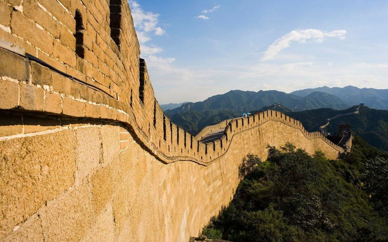
For the final stretch of this segment, scattered sections of the Han dynasty Great Wall run alongside the G312 — mud-brick ramparts several meters high still standing in the desert after 2,000 years. Seeing them from the saddle, without other visitors around, is among the quieter moments of the route.
Explore the Full 12-Day Yaso Trip Itinerary
Tour Route:Lanzhou-Wuwei-Zhangye-Jiuquan-Jiayuguan-Yumen City-Dunhuang
12 Days 8 Places View DetailSegment 4: Jiayuguan to Dunhuang — The Desert Final Push
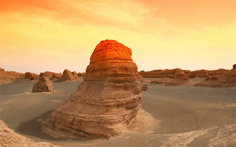
The final segment is the longest and most isolated: roughly 390 km (242 miles) over three to four days through the Gobi Desert. The last 120 km (75 miles) from Guazhou (瓜州, Guāzhōu) to Dunhuang runs through the open Gobi with no services — the route's one genuinely committing stretch.
 Gobi desert approaching Dunhuang
 Dunhuang Mingsha Shan singing sand dunes aerial
Fact Panel
- Route: Jiayuguan → Guazhou → Dunhuang
- Distance: ~390 km (242 mi)
- Elevation: 1,740–1,139 m (5,709–3,737 ft) — gradual descent overall
- Duration: 3–4 days
- Best Time: September–early October
- Difficulty: High (isolation, 120 km service gap, wind exposure, desert heat)
- Highlights: Yumenguan ruins, Mogao Caves, Crescent Moon Lake, Singing Sand Dunes
- Resupply: Guazhou is the last full-service stop before Dunhuang; carry 2 days of water from Guazhou
West of Jiayuguan, the Hexi Corridor opens fully into the Gobi. The landscape here is gravel flat and vast — wind turbines in rows stretch to the horizon, power lines run parallel to the road, and the Qilian Mountains recede into the south. The cycling is straightforward but mentally demanding; there is very little to break the rhythm except distance itself.
Guazhou (historically known as Anxi, 安西) serves as the final resupply before Dunhuang. The 120 km (75 miles) of Gobi that follow are paved and mostly flat, but entirely without services. The support vehicle carries water reserves for this section — riders should plan for significant wind exposure and strong UV.
Cyclists approaching Dunhuang from the east pass near the ruins of the Yumenguan (玉门关, Yùménguān) — the "Jade Gate Pass" of Han dynasty poetry, the westernmost extension of the original Han Great Wall and the departure point for caravans heading into Central Asia. As of 2025, the site is accessible as a day trip from Dunhuang; foreign visitors should check current access status, as restoration work has occasionally affected entry.
Dunhuang (敦煌, Dūnhuáng) announces itself as an oasis: date palms and poplar trees appear along the road, then the city itself — busy, modern, built around tourism but unmistakably real in its desert setting. The Mogao Caves (莫高窟, Mógāo Kū), 25 km (16 miles) southeast of the city, represent the journey's culmination. Carved into a cliff face from the 4th through 14th centuries, 492 caves survive with murals and sculptures spanning the Tang, Song, and Yuan dynasties. Daily visitor numbers are capped at 6,000. Foreign passport holders cannot book tickets through Chinese online platforms independently — Yaso Trip handles advance reservations for group participants, which is a meaningful practical advantage given the ticketing constraints.
The Singing Sand Dunes and Crescent Moon Lake (鸣沙山月牙泉, Míngshā Shān Yuèyá Quán) are Dunhuang's other iconic landmark: a 40 m (131 ft) dune curling around a crescent-shaped spring that has somehow persisted for centuries despite the encroaching sand. At sunset, the dunes glow amber and the wind draws sound from the surface — the source of the "singing" that gives the formation its name.
If you plan to continue cycling west from Dunhuang into Xinjiang, the Inner Mongolia–Gansu–Xinjiang corridor route via Hami is covered by a separate product:
Tour Route:Bayannur-Alxa League-Ejina Banner-Hami-Shanshan
10 Days 10 Places View DetailFor those considering the full Silk Road from Xi'an to Urumqi — the historical caravan route in its entirety — a 28-day expedition is also available:
Tour Route:Xian-Pingliang-Dingxi-Lanzhou-Wuwei-Zhangye-Jiuquan-Jiayuguan-Yumen City-Dunhuang-Hami-Turpan-Urumqi
28 Days 15 Places View DetailPractical Logistics
Best Time to Cycle the Hexi Corridor
September to early October is the optimal window. September delivers warm days — 14–29°C (57–84°F) at Zhangye, slightly cooler further west — with good visibility and post-harvest golden scenery in the corridor's agricultural sections. The sandstorm risk that peaks in April–May is largely absent.
Early October brings cooler nights, excellent photography light, and thinner crowds at major attractions outside the National Holiday week (October 1–7 is extremely busy at Zhangye Danxia, Jiayuguan Fort, and the Mogao Caves — plan around it if possible). By late October, desert nights drop toward 0°C (32°F).
Avoid July–August: temperatures in the Dunhuang basin reach 38–42°C (100–108°F), and UV intensity at the corridor's 1,100–1,700 m elevation is severe.
G312 vs G30 — Which Road to Ride
Cycling on the G30 Lianhuo Expressway is illegal throughout Gansu. Police patrol the expressway and will escort cyclists off at the next exit. The G312 National Highway runs parallel for the full route and is primarily well-paved asphalt. In a small number of sections, the G312 has roadworks or rougher surface — a manageable inconvenience compared to the risks of the expressway.
The G30 Lianhuo Expressway runs parallel to the G312 for much of the Hexi Corridor. Cycling on any Chinese expressway is illegal. Police on the G30 actively enforce this and will remove cyclists from the highway, regardless of how smooth the road looks. The G312 is the only legal cycling route for the full corridor.
Permits and Documentation
No special cycling permit is required to cycle through Gansu Province on the G312. A standard Chinese tourist visa suffices for most nationalities (or qualifying visa-free entry). Unlike Tibet or border-zone routes in Xinjiang, the Hexi Corridor does not require additional permits for foreign cyclists.
For an accurate cost breakdown tailored to your group size, dates, and preferences, contact the Yaso Trip team for a custom quote.
Key Attraction Reservations
Mogao Caves: The daily 6,000-ticket limit makes advance booking essential in the April–November peak season. Foreign passport holders cannot book through the official Chinese platform. Yaso Trip manages group reservations directly — one of the clearest practical advantages of cycling the corridor with a licensed operator.
Zhangye Danxia: No advance reservation typically required, but sightseeing buses within the park fill up by mid-morning during peak season. Arrive by 08:00 for the best experience.
Jiayuguan Fort: Walk-up tickets available. Arrive in the first two hours of opening to cycle around the fort's outer perimeter before tour groups arrive.
Sandstorm Protocol
Sandstorms (沙尘暴, shāchénbào) in the Hexi Corridor are most common April–May but can occur unexpectedly at any time of year. The protocol: monitor weather the evening before each stage, receive a morning briefing from your guide, and board the support vehicle immediately if conditions deteriorate. Riding in a sandstorm is neither safe nor useful — it is the support vehicle's primary job on such days.
12-Day Silk Road Gansu Cycling Itinerary
12-Day Silk Road Hexi Corridor Cycling Itinerary
Day 1-2
Lanzhou → Kushui & Wushao Approach
Depart Lanzhou, ride northwest on G312 through Yongdeng to Kushui. Camp or stay near Shuiying Danxia canyon — spectacular colorful formations with almost no other visitors.
Day 3-4
Tianzhu → Wushao Pass → Wuwei
Climb through Tianzhu Tibetan County (white yak cuisine stop), cross Wushao Pass at 3,030 m (9,940 ft), descend into Wuwei. Afternoon: Flying Horse tomb, Kumarajiva Temple, ancient Liangzhou quarter.
Day 5-6
Wuwei → Yongchang → Shandan
The route's hardest sustained day: 106 km Yongchang-Shandan with 50 km of gradual headwind climb. Early start essential. Support vehicle standing by. Arrive Shandan by mid-afternoon.
Day 7
Shandan → Zhangye & X038 Detour
Flat ride into Zhangye via the X038 county road — willow-canopied lane through sunflower and cornfields. Arrive Zhangye; rest afternoon.
Day 8-9
Zhangye: Danxia + Gaotai → Jiayuguan
Morning: Zhangye Danxia Geopark (shuttle bus required; go early). Afternoon ride toward Gaotai — county museum with Wei-Jin murals. Continue to Jiayuguan. Evening: walk to fortress gate.
Day 10
Jiayuguan Fort & Westward
Full Jiayuguan Fort visit at opening (¥110 high season). Afternoon ride west through open Gobi, Han Great Wall mud ruins alongside the road.
Day 11-12
Guazhou → Dunhuang
Guazhou resupply (last services). 120 km Gobi crossing to Dunhuang — carry water. Arrive Dunhuang. Final day: Mogao Caves (pre-booked), Singing Sand Dunes, Crescent Moon Lake at sunset.
Tips & Cautions for Hexi Corridor Cyclists
- Start every day early. Wind on the Hexi Corridor intensifies through the afternoon, particularly in the Gobi sections. A 07:00 start covers the day's hardest distance before headwinds peak.
- Pace the Wushao Pass. The climb to 3,030 m (9,940 ft) is the route's only genuine elevation challenge. There is no need to rush. Spin a low gear, eat frequently, and stay hydrated — the descent rewards patience.
- Treat the Yongchang–Shandan stage as a maximum-effort day. 50 km of gradual incline in sustained wind requires full pacing discipline from the first pedal stroke. Riders who attack it typically blow up by kilometer 60.
- Protect against the sun. UV intensity at 1,500–1,740 m (4,900–5,700 ft) in the open Gobi is severe. Apply SPF 50+ before each stage. Arm sleeves and a sun-shield balaclava are not optional in July–August; they are strongly recommended in September as well.
- Carry water beyond what you think you need. The Guazhou–Dunhuang stretch is 120 km (75 miles) with no refill points. The support vehicle carries reserves on guided tours, but solo or self-supported cyclists should carry 4+ litres per person minimum.
- The G312 is your only road. Every time the expressway looks tempting on a rough G312 section, remember that police will remove you and the surface often returns to new pavement within a few kilometers.
- Check weather the night before. The Gansu Meteorological Bureau app or your guide's local contacts will give you 12–24 hours notice of sandstorm or extreme wind conditions.
- Mogao Caves require advance booking. Do not arrive in Dunhuang without tickets. The daily cap of 6,000 means walk-up availability disappears quickly in peak season. Tour participants have this arranged in advance; independent cyclists should book through an agency or international platform well ahead of arrival.
Why Travel the Hexi Corridor with Yaso Trip
Wind management is the core skill. Westbound headwinds define this route — they are strongest in the afternoon, most intense in the Jiayuguan-to-Dunhuang final stretch, and can transform a reasonable day into a demoralizing one without the right staging. Yaso Trip's itinerary is built around wind-aware timing: early morning starts, flexible stage lengths, and a support vehicle protocol that lets riders rest during the route's worst sustained headwind periods without abandoning their progress.
Mogao Caves access. Foreign passport holders cannot book Mogao tickets through the Chinese online platform. With the daily 6,000-ticket limit, peak-season walk-up access is increasingly unreliable. Yaso Trip arranges group reservations directly, which removes the route's most frustrating logistical variable entirely.
The insider route. Kushui Shuiying Danxia, the X038 rural canopy road, Gaotai's mural museum, Tianzhu's white yak cuisine, Wuwei's ancient Liangzhou quarter — none of these appear in standard Hexi Corridor guides. They are in the itinerary because the team has ridden this route repeatedly and discovered what makes the corridor extraordinary beyond the three headline attractions.
Bilingual support and logistics. Payment infrastructure, accommodation registration for foreign passports, permit coordination, mechanical support, and local knowledge of conditions — the Hexi Corridor is navigable independently, but the friction points accumulate over 12 days in a way that guided support meaningfully reduces.
Ready to Ride the Silk Road?
The Hexi Corridor is one of China's most historically meaningful cycling routes — not because of extreme altitude or technical difficulty, but because of where it takes you and what it lets you see at human speed across 1,100 km (684 miles) of the ancient world's most important highway. Yaso Trip's 12-day tour handles the planning, permits, and logistics so riders can focus on the ride and the history.
FAQs about Silk Road Hexi Corridor Cycling
Expand All1. How long does it take to cycle the Hexi Corridor from Lanzhou to Dunhuang?
The Hexi Corridor from Lanzhou to Dunhuang covers approximately 1,100 km (684 miles). The guided tour covers this distance in 12 days. Independent cyclists typically take 14–20 days depending on daily distance targets, rest days, and detour time at attractions.
2. What is the best time of year to cycle the Hexi Corridor?
September to early October is the optimal window: temperatures of 14–29°C (57–84°F), good visibility, post-harvest scenery, and the lowest sandstorm risk. Avoid April–May (sandstorm peak) and July–August (extreme heat reaching 40°C / 104°F in the Dunhuang basin).
3. Do I need any special permits to cycle through Gansu to Dunhuang?
No special cycling permit is required for the Gansu section of the Hexi Corridor. A standard Chinese tourist visa (or visa-free entry if eligible for your nationality) is sufficient. Unlike Tibet, there is no regional permit for foreign cyclists on this route.
4. Can I continue cycling west from Dunhuang into Xinjiang?
Yes. From Dunhuang, the G30 and the historic route continue west toward Hami in Xinjiang. The desert section between Dunhuang and Hami is extremely isolated with very long resupply gaps. A supported option for the westward extension covers the Linhe-to-Hami corridor via the Inner Mongolia–Gansu–Xinjiang route.
5. Is the road surface good on the G312 through Gansu?
The G312 through Gansu is predominantly good-quality tarmac, with occasional rough sections during active roadworks. It is significantly better surfaced than comparable national highway stretches in parts of Xinjiang or Qinghai. The occasional temptation to use the parallel G30 expressway should be resisted — cycling on the expressway is illegal and police actively enforce the rule.


 View All China Tours



 View All China Theme Tours by Interest


 Home


